
Verified Views & AVR Planning Services London
Expert verified views and accurate visual representations for UK planning applications—RICS-regulated chartered surveyors delivering Landscape Institute compliant AVR services since 1996.

Planning Authority Requirements Across London
Verified views originated with Westminster City Council and the City of London Corporation, who pioneered their use for protecting sensitive historic environments. Today, planning authorities across London have varying AVR requirements:
✓ City of London Corporation - Comprehensive verified views required for all major developments
✓ Westminster City Council - Strict AVR compliance for conservation areas and tall buildings
✓ Camden, Islington, Southwark - Project-specific verified view requirements
✓ Emerging authorities - Increasingly adopting verified view standards for visual impact assessment
Our 40 years of chartered surveyor experience ensures full compliance with each planning authority's specific requirements, from initial scoping to final submission.
Full AVR Service
- Surveyed camera positions
- Accurate 3D modeling
- Comprehensive methodology statements
- Full compliance with Landscape Institute guidance
- Expert liaison with planning authorities
Expert Verified View Solutions
RICS-Regulated Professional Standards
As Members of the Royal Institute of Chartered Surveyors (RICS) and following official Landscape Institute guidance, we deliver verified views that meet the highest professional standards:
✓ RICS-regulated accuracy and surveying methodology
✓ Full compliance with Landscape Institute AVR guidance and best practice
✓ 40 years of chartered surveyor experience in visual impact assessment
✓ Direct professional liaison with planning authorities across London
✓ Comprehensive method statements and technical documentation included
✓ Professional indemnity insurance covering all verified view services

Verified Lite
- Accurate view creation
- Documented methodology
- Cost-effective solution
- Suitable for less sensitive sites
- Transparent assumptions

Understanding AVR Levels: From Basic Outlines to Photorealistic Renders
The Landscape Institute defines five levels of Accurate Visual Representation (AVR), each serving different planning purposes. We help determine the appropriate level based on your development's sensitivity, location, and planning authority requirements.

AVR - Level 0
Location and size.
The most basic level showcases the location and size of the proposed development by overlaying an outline of the building over a street-view photograph of the proposed development site.

AVR - Level 1
Location, size and degree of visibility.
Level 1 builds on Level 0, by shading the outline in the outline of the building and showing off the visibility of the building from specific angles.
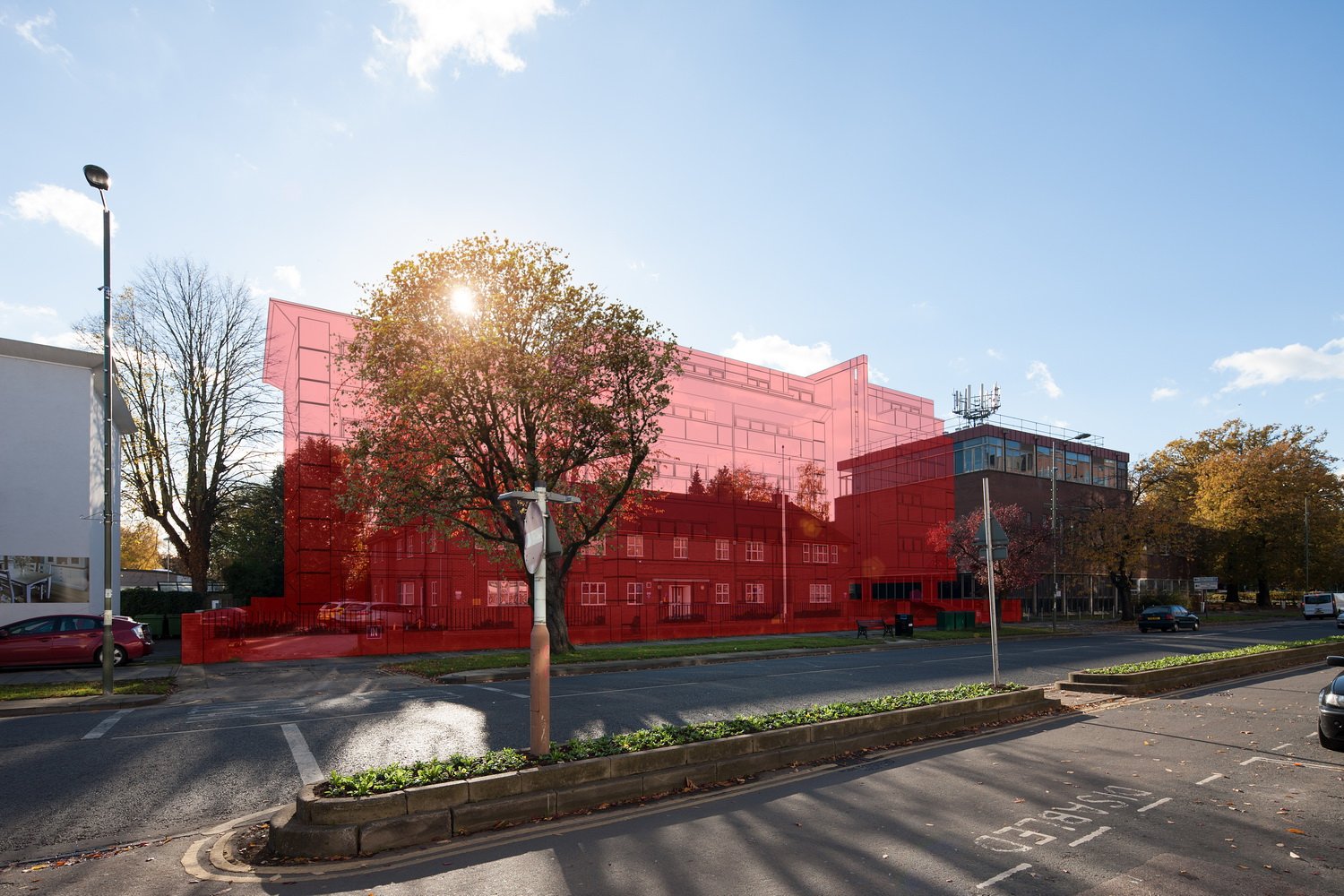
AVR - Level 2
A hint of architectural form.
In level 2, we incorporate a semi-transparent architectural drawing of the proposed development that shows the degree of visibility of the proposal.
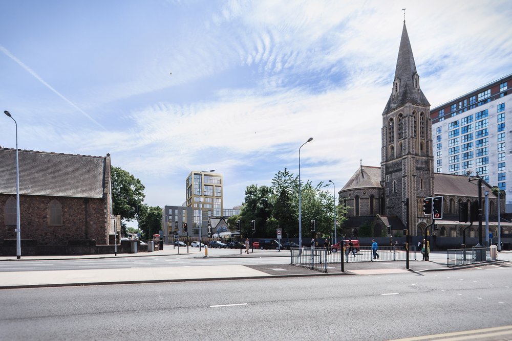
AVR - Level 3
Showing the Architectural Detail.
It is Level 2, where we start to show off the architectural form of the building by imposing a 3D grey model of the building onto a photograph.
AVR - Level 4
Showing the final finish.
This is the most detailed level of accurate visual render of your development, where we photomontage the building into the photo, accurately you showing off the materials and finishes that will be used in the final build.
For further guidance, see
Landscape Institute
Trusted by Leading property developers
Over the past 25 Years we have produced CGIs and planning assets for many companies, who are responsible for planning London into what it is today. Our commitment to delivering top-notch work efficiently has earned us the loyalty of our clients, who consistently return for more.


Frequently Asked Questions- Verified Views
-
Verified Views are accurate visual representations (AVRs) of how a proposed development or building will look within its intended surroundings. They are created by integrating 3D models of the proposed design with photographs of the existing environment and accurate on site survey data Verified Views are commonly used for planning applications to help stakeholders understand how the development will impact the surrounding area.
-
The purpose of Verified Views is to provide a realistic visual representation of how a proposed development will look in its intended environment. They are used to assess the visual impact of the proposed design, to help stakeholders understand how the development will look in context, and to support planning applications and landscape assessments.
-
Verified views may be required, but it varies depending on the planning authority and the sensitivity of the development. If the development is sensitive, we offer a verified lite which illustrates the assumptions, care and attention we apply to each view.
-
Verified Views and AVRs are created by integrating a 3D model of the proposed development with photographs of the existing environment and accurate survey data (camera position and surrounding buildings) . The 3D model is accurately positioned and scaled to match the perspective of the photograph, and then rendered to create a photorealistic image of the proposed development in situ. The resulting image is then verified by an independent assessor to ensure that it is an accurate representation of how the development will look in reality.
-
Yes, we can provide a detailed method statement, including the photos and survey data used to verify the view accurately.
-
Developers, architects, planners, and other stakeholders involved in the planning and design process may need Verified Views. They are commonly required as part of planning applications for major developments, such as new housing developments, commercial buildings, and infrastructure projects.
-
Verified Views can be used to support planning applications, to help stakeholders understand how a proposed development will impact the surrounding area, and to demonstrate compliance with planning policies and guidelines. They can also be used for marketing purposes, to help promote a development to potential investors, buyers, or tenants.
-
The benefits of using Verified Views or AVRs include improved understanding of the visual impact of a proposed development, reduced risk of objections or delays during the planning process, improved communication between stakeholders, and increased confidence in the design.